NWS increases tonight’s severe storm risk to ‘enhanced’
Published 2:30 pm Saturday, April 13, 2019
|
Getting your Trinity Audio player ready...
|
The National Weather Service is urging Alabamians to be aware of weather conditions tonight and into the morning hours Sunday.
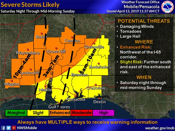
Law enforcement, fire personnel and emergency management officials from Butler County and Greenville met this afternoon and listened to a webinar from the National Weather Service in Mobile. According to the forecast, Butler County is now in an area for an enhanced risk of severe thunderstorms that could include high winds, hail and even tornadoes.
“This is one of the more significant events we’ve had in a while,” the NWS presenter said.
The I-65 corridor, including Greenville, was moved into the enhanced risk area from the “slight” risk first noted Friday during a late afternoon webinar.
NWS officials say there is a bit of good news – the storms may be out of the area earlier than expected as they’ve moved the storm’s exit from around noon to 9 a.m. or so in a line from Greenville to Destin, Fla.
The storms are expected to move into the Butler County area during the late evening and we could see 20-30 mph wind gusts ahead of the front.
As of mid-Saturday, the storms were in central Texas headed for Louisiana and Mississippi. Meteorologists said the atmosphere was “getting really unstable,” though they are expecting the most severe storms to be west of Greenville and Butler County.