Major flooding, wash outs, downed powerlines, fallen trees plague Crenshaw County is wake of Sally
Published 9:03 pm Thursday, September 17, 2020

Williams Loop

School Drive

In Front of Brantley School

Brantley baseball fields

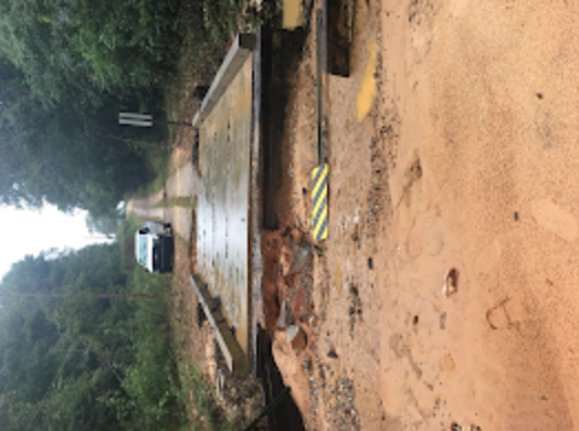
Cameron Chapel Rd.

Mt. Ida Rd.

S. Glenwood Rd.

County Road 59

Swanner Bridge Road

County Road 59

Williams Loop
|
Getting your Trinity Audio player ready...
|
South Crenshaw County saw major flooding from Tropical Storm Sally on Wednesday.
The storm dumped copious amounts of rain on the county.
EMA Director Elliott Jones said that Brantley received about 20 inches of rain, Luverne received 12 inches and Highland Home received 10 inches of rain.
Jones said there was one swift-water rescue in the Dry Creek area just north of Brantley on Hwy. 331.
Damages range from fallen trees to undermining of road ways to major flooding and downed power lines. The list is extensive.
Crenshaw County officials lifted an impassable road advisory Thursday afternoon.
“There are several areas with damage and some roadways are completely closed,” Jones said. “ It is very important to continue to use extreme caution when traveling. Although preliminary assessments are complete, that does not mean that there aren’t some areas that are problematic that have not been located.”
The following roads are closed until further notice;
- Williams Loop;
- Mount Road;
- Swanner Bridge Road;
- Mt. Ida Road;
There were multiple fallen trees reported including:
- Moody’s Crossroads;
- Honoraville Road;
- Leon Tower Road;
- 332 Country Ln. Court (powerline down, as well);
- Ivy Creek Road;
- New Ebenezer Road at New Ebenezer Church;
- 2203 Glenwood Road;
- 95 Dawson St.;
- 3900 Glenwood Rd.;
- 54 S. Martin Ave.;
- 2526 Glenwood Rd.;
- 899 Spring Hill Rd.;
- Mt. Ida Rd.;
- Battle Rd.;
- Patsburg Hwy;
- Quail Tower Rd.;
- Opp Hwy.;
- Hwy. 189 at Powell Rd.;
- W. 9th Street at Woodford Avenue, Luverne;
- 1928 Bowden Rd., Honoraville;
- Weed Road;
- 290 Leon Tower Rd., Dozier;
- Georgiana Hwy.;
- Dozier Hwy. (with downed powerlines);
- Moseley Mill Road;
- Mothershed Road;
- Davenport Hwy;
- Live Oak Road;
- Post Office Loop;
- Norman Road;
- Mayberry Gulley Road (with downed powerlines);
- 1100 Cook Trail (with downed powerlines);
- Odom Loop Road;
- Moodys Pond Road;
- Siloam Church Road;
Downed powerlines;
- Clements Avenue;
- Montgomery Hwy.;
Flooding
- East Emmett Ave., Brantley;
- School Drive, Brantley;
- 1174 S. Moodys Crossroads;
- 14236 Dozier Hwy.;
- School Loop Drive and Brantley High School;
- Fulton Avenue, Brantley;
- 6816 Mt. Ida Rd. (major flooding);
- Brantley Hwy. (major flooding);
- S. Glenwood Road (major flooding);
- Norman Road;
- Swanner Bridge Road;
Road Washouts
- Kimbro Road (Bridge approach wash out);
- South Franklin Road;
- Beat 12 Road;
- Williams Loop Site 1;
- Cameron Chapel Road (shoulder and front slope washed out and undermining);
- Mt Ida Road; (Double X-drain pipe washed out);
- S. Glenwood Road (Shoulder and front slope washed out and undermining);
- County Road 59 site 1 (shoulder and front slope washed out and X-drain partially collapsed);
- Mt. Road
- County Road 59 site 2 (culvert wing washed out);
- Williams Loop (X-drain washed out);
- Williams Loop Site 2 (X-drain washed out);
Power outages were widespread, as well.
- South Alabama Electric Cooperative reported 1,700 customers without power, as of 8 p.m., Thursday, there were 68 members affected by the power outage in the entire SAEC system, according to its outage map. Crews from Pea River Electric Cooperative and Wiregrass Electric Cooperative assisted linemen from SAEC in the restoration effort.
- Covington Electric Cooperative reported 3,700 meters without power Wednesday afternoon, and as of 8 p.m., there were 13 meters without power. CEC crews were still working to resolve more outages. CEC officials report that there are some areas that cannot receive power yet due to damage. They were assisted by Lee Electric.