Cartographer headlines quarterly Butler County Historical Society meeting
Published 5:54 pm Tuesday, November 1, 2016
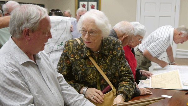
Historical society member Ann Feathers confers with map expert Craig Remington about a map brought from home following Remington’s presentation Sunday. The director of the UA Cartographic Research Lab brought copies of a number of maps of local interest to donate to the research room.
Craig Remington is a man who loves maps. As the longtime director of the University of Alabama’s Cartographic Research Lab, he is considered one of the country’s foremost authorities on all aspects of map making. On Sunday, Remington shared with members and guests at the Butler County Historical Society’s quarterly meeting some of that vast store of cartography knowledge—not to mention quite a few of the maps the adjunct professor has collected during his tenure at the university.
“I have scanned in copies of 70,000 or so maps by now,” he told his audience.“While it’s predominantly this state and the southeastern United States, this collection includes maps from across the country and around the world.”
Among the maps of particular interest to his Camellia City audience were a large Birmingham News map of the state dating back to the early 20th century, flanked by portraits of Alabama’s governors; aerial photos of Greenville from more than a half-century ago; a state map from the antebellum era featuring steamboat routes and a post-Civil War state map showing railway stops, including several in Butler County.
Maps can reflect the relative prosperity or lack thereof at the time they were created.
“If you look at the land survey plats from the Great Depression, you will note quite often few individuals own land. Most of it is in the hands of the timber companies, banks or insurance groups,” said Remington.
He pointed out the maps from Alabama’s territorial days often display a great deal of “no man’s land” between the more densely settled and meticulously surveyed regions to the north and south.
While today’s maps are digital creations with all the bells and whistles, map making was once a truly laborious process done entirely by hand.
“And when you see an older colored map, that coloration was also done by hand,” Remington said. “the color lithographic process came after the mid 19th century.”
Artistic flourishes would be added to maps going to the well-heeled. Some of the maps dating back to the 16th and 17th centuries are quite ornate, Remington said, making them suitable for hanging on the wall of one’s home “to impress your guests with how worldly and cultured you were.”
Many maps were once bound into atlases, the publishing of which provided the livelihood for cartographers. Later, these maps were often removed from the volumes and sold individually (“which is why you see so many old maps that are book size, Once upon a time, they were in a book”). And many of the best and most reliable early U.S. Atlases were actually British-made, said Remington, adding, “They weren’t really in the mood right after the Revolution to make atlases for us, but that had changed by the 1790s.”
Historically, all maps were not created equally. “You do have to remember some territories changed hands several times . . . whoever happened to be in control of it at the time would be most likely to have the most accurate map,” Remington explained. “A French-made map of what was then a English-held territory, for example, is going to be a little suspect.”
The man who loves to glean glimpses of history from maps has also compiled information about place names and cemeteries throughout Alabama into two books, both now available to download as PDFs.
To explore some of the historical and contemporary maps including land survey plats, Department of Defense maps, maps of waterways and cities and counties in the University of Alabama’s extensive collection, go to alabamamaps.ua.edu. Remington’s atlases of place names and cemeteries can also be accessed on this site.