Hurricane Matthew leaves path of destruction
Published 10:23 am Thursday, October 13, 2016
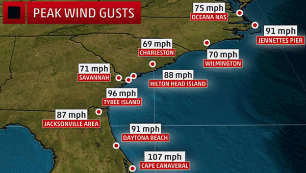
Pictured are the peak wind gusts in the areas of Florida, Georgia, South Carolina, Virginia and North Carolina as a result of Hurricane Matthew.
Over the past few days, more and more information regarding Hurricane Matthew has circulated, but according to local weather professionals there is little chance of Crenshaw County seeing the storm firsthand.
“According to my sources with the NWS in Mobile, there is very little probability that the remnants of Hurricane Matthew will reform or loop back towards our area,” said Crenshaw County Emergency Management Agency Director Elliott Jones.
“As for now we are safe. As this hurricane season has already shown itself to be very active, I will keep in close contact with Mobile so that I can keep the public informed.”
On Oct. 7 in Florida, a peak surge of 9.88 feet above normal was measured at a National Ocean Service (NOS) tide gauge at Fernandina Beach, Florida.
Storm surge flooding affected the St. Augustine area, including major flooding on Anastasia Island where water was reported to be 2.5 feet above ground level. To the south in nearby Flagler Beach, Florida, parts of the area were washed out by the storm surge.
“We have to stay prepared at all times. The path of this storm could have very easily involved our area,” Jones said.
“Hurricane season is still active until the end of November, so we do not need to let our guard down.”
The NWS-Jacksonville conducted a storm survey and found a new inlet was carved between Marineland and Matanzas Inlet, between Palm Coast and St. Augustine Beach, Florida.
The St. Johns River in northeast Florida reached its highest level on record at Shands Bridge, along with three to 4.3 feet of storm surge inundation reported at the Racy Point, Red Bay Point and I-295 bridge tide gauges. Early in the morning on Oct. 8, the St. Johns River was flowing backwards.
Matthew’s storm surge coupled with high tide lead to a record tide level at Ft. Pulaski, Georgia, early Oct. 8, and storm surge inundation roughly waist-deep was reported in parts of Charleston, South Carolina.
Jones stated that across five states, nearly 7,000 people woke up Monday morning in 156 Red Cross and community emergency shelters: in North Carolina there were 72 shelters with 1,850 people; in South Carolina there were 41 shelters with 1,780 people; in Georgia there were 19 shelters with 2,830 people; in Florida there were 21 shelters with more than 440 people; and in Virginia there were three shelters with 60 people.
According to Jones, the death toll in the US has reached 21 and 1,027 total as of Tuesday.
“If anyone would like further information on how to properly prepare for a hurricane or any other type of disaster, please feel free to stop by the office or give us a call,” Jones said.